Barrowland Lane Bridge
This bridge lies on the former Bridport to Maiden Newton line, the last broad gauge line to be constructed in Dorset.

Share this article
Location: Toller Porcorum, Dorset
Status: Awaiting decision from Dorset County Council on best course of action to alleviate flooding issues. This will inform any work to the bridge and access routes to the existing multiuser path
History
The Bridport railway was a branch line linking Bridport with the mainline at Maiden Newton. It opened on 12 November 1857 after two years of construction, being the last broad gauge railway to be built in Dorset.
The Beeching Report recommended the line’s closure due to annual losses of around £54,000 but a subsidy from the local council maintained passenger services immediately following the report’s publication. A public enquiry eventually led the Secretary of State for the Environment to authorise the line’s closure in May 1975, with the track lifted a few months later.
About the structure
The bridge carries the former railway line over Barrowland Lane and is a relatively typical trough deck construction. Whilst the deck itself is not in an unreasonable condition, the substructure contains numerous fractures and its abutments are causing fracturing and global bulging below the bearing shelf.
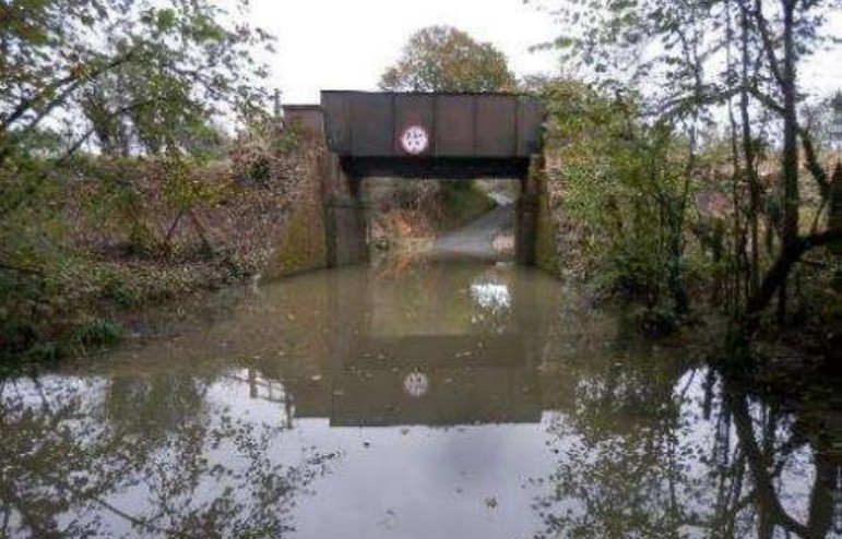
The road under the bridge forms a sump which has seen regular flooding over several decades, causing major disruption to the local community. The structure also has a substandard headroom of 3.5m compared to the required minimum maintained headroom of 5.03m for all existing bridges, limiting its use.
The former track bed now forms part of a multi-user path that terminates at the eastern side of bridge. A bridleway continues on the western side of Barrowland Lane, beginning on a slightly different alignment to the former track bed, but rejoining it after a few hundred meters. Access to the path from Barrowland Lane is possible, although the council plan to create a more shallow ramped access point should the bridge be removed as part of the flood alleviation works.
What is the project?
National Highways was approached by Dorset Council and asked to demolish the bridge to allow a shallower ramped access point to the active travel route on the track bed to the west to be created. The council also noted that demolition works would allow the carriageway to be reprofiled, preventing flooding that has affected local communities for decades.
We agreed to discuss the options for this bridge at our Stakeholder Advisory Forum (SAF). This initial discussion in October 2022 saw the forum discuss three options for the structure’s future:
- Undertake no significant works but continue to regularly examine and monitor the bridge
- Repair the substructure and stabilise the bridge
- Demolish the bridge
With the first and second options, the issue of flooding would remain. It was made clear in this meeting that demolition is not something National Highways would need to undertake to deliver our remit and that it had been brought to the forum as an option as the local council had requested it to be considered to fit with their active travel and road re-profiling plans.
The forum recommended that National Highways investigate the transfer of the bridge to the local council and the possibility of repairing and stabilising the bridge. Unfortunately, neither of these options were deliverable, as the council declined to take on ownership of the structure, and the adjacent landowner refused to allow works on their land that would be necessary to stabilise the bridge.
Since then, we have continued to engage with Dorset Council and Toller Porcurum Parish Council regarding the bridge’s future. The members of the SAF have been regularly updated on these discussions.
What stage is it at?
The local parish council voted to recommend the removal of the deck and the reprofiling of the road. We continue to engage with local communities, the parish council and the county council around long-term solutions to create access to the active travel route and alleviate the flooding under the bridge.
Drainage is the responsibility of the county council, and to combat this, demolition continues to be their preferred option. We are yet to decide on whether to proceed with demolition, though will update both this page and the SAF regularly on the bridge’s future.
